16
SAC-00-094
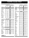
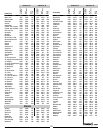
Resolution Is. 259 12.2 110 263 10.9 112
Somerset Is. 226 8 94 230 7.7 95
Southampton Is. 230 14.9 101 234 14.2 102
Spence Bay 212 11.4 95 216 11 97
Tavani 200 18.9 97 204 18.3 99
Wager Bay 213 14.7 97 217 14.1 99
Whale Cove 201 18.3 97 206 17.8 99
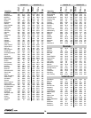
Arctic RedRiver 120 11.6 79 124 12.3 81
Banks Is. 126 7.9 86 130 8.2 87
Fort Franklin 132 15.3 83 136 15.8 84
Fort Good Hope 126 13.6 81 130 14.2 82
Fort Liard 136 20.3 81 140 20.9 83
Fort Norman 130 15.4 82 134 15.9 83
Fort Reliance 158 19 89 162 19 91
Fort Simpson 138 19.1 83 142 19.6 85
Fort Smith 154 21.8 87 159 21.9 90
Ft McPherson 120 11.4 79 124 12.1 80
Ft Providence 143 20 84 148 20.3 86
Ft Resolution 150 20.5 87 155 20.7 89
Hay River 147 20.7 85 151 20.9 87
Holman Island 135 10.5 86 139 10.7 88
Inuvik 120 10.9 80 124 11.5 81
Jean Marie Rvr 139 19.4 83 143 19.9 85
Melville Is. 144 6 89 148 6 90
Nahanni Butte 135 19.5 81 140 20 83
Norman Wells 129 14.8 81 133 15.3 83
Port Radium 139 15.1 85 143 15.3 87
Rae 145 18.6 86 149 18.8 87
Snowdrift 155 19.4 88 159 19.4 90
Tuktoyaktuk 120 10 81 124 10.5 82
Victoria Is. 149 10.5 89 154 10.5 90
Wrigley 134 17.3 82 138 17.8 84
Yellowknife 148 19 86 152 19.2 88
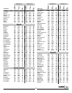
Big Salmon 122 2216.3 76 127 17.2 78
Carmacks 121 15.8 75 125 16.7 77
Dawson 118 13.3 75 122 14.3 77
Forty Mile 117 12.8 75 121 13.7 77
Keno Hill 121 14.4 77 125 15.2 79
Klondike 118 13.4 75 122 14.3 77
Mayo Landing 121 14.5 77 125 15.3 78
Old Crow 116 10.3 77 120 11.1 79
Stewart River 118 14 75 122 14.9 76
Tagish 124 17.9 75 128 18.9 77
Teslin 125 18.5 76 129 19.3 78
Watson Lake 129 19.4 78 134 20.2 80
Whitehorse 123 17.4 75 127 18.3 77
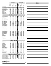
Prince Charles Is. 254 10.3 102 258 9.5 103
Prince of Wales Is 197 8.3 93 201 8.1 94
Prince Patrick Is. 121 4.2 87 125 4.3 88
Queen Elizabeth Is 256 2.9 92 259 2.8 93
Compass
Azimuth
Dish
Elevation
Dish
Skew
Town/City
Satellite ‘A’ Satellite ‘B’
Compass
Azimuth
Dish
Elevation
Dish
Skew
Notes
Northwest Territory
Yukon Territory
Canadian Arctic Islands


