


Chapter 8 UMID Functions
Chapter 8 UMID Functions 8-5
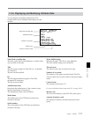
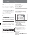
4 Date/Time
Date/Time data is displayed across two lines.
The upper line shows the MJD (Modified Julian Date)
contained in the Source Pack, converted to UTC.
The lower line shows the data in unit count format
(hours : minutes : seconds : frame) converted to UTC.
Note
The function for converting unit count to UTC works
only when the unit rate is 2 (24 frames), 3 (24/1.001
frames), 4 (25 frames), 6 (30 frames), or 7 (30/1.001
frames). For other unit rates, the unit rate number and
unit rate are displayed in hexadecimal.
5 Altitude
XXXXXXXXm: Altitude data indicating the distance
from the center of the earth is displayed in this
format.
S+XXXXXXXm Y+D: Altitude data indicating the
distance from sea level is displayed in this format.
The meaning of the characters and strings shown
is as follows.
• “S” (1st character): Indicates data from a Sensor.
“R” is shown for position data from the
recording device (Recorder), and “T” is shown
for Target position data.
• “+” (2nd character): Indicates higher than sea
level. “–” indicates lower than sea level.
•“XXXXXXXm” : Altitude data (unit meters).
•“Y”: The number of satellites used to calculate
position data (hexadecimal).
•“D”: DOP (dilution of precision) value.
• “+” (between Y and D): Displayed when a
supportive apparatus was used. A space (blank)
is displayed when no supportive apparatus was
used.
6 Longitude
Following “W” to indicate west longitude or “E” to
indicate east longitude, the longitude is displayed in
degrees, minutes, and seconds (seconds are shown up
to 2 decimal places).
Example: “E134 59’23.00” for “East longitude 134
degrees 59 minutes 23.00 seconds”
7 Latitude
Following “N” to indicate north latitude or “S” to
indicate south latitude, the latitude is displayed in
degrees, minutes, and seconds (seconds are shown up
to 2 decimal places).
Example: “N34 59’23.32” for “North latitude 34
degrees 59 minutes 23.32 seconds”