


17
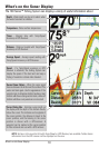
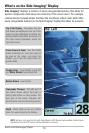
What’s on the Side Imaging® Display
is connected to the 700 Series™ Fishfinder. If both devices are connected, then only the
accurate interpretation of bottom contour and structure. For Side Imaging®, the
rock and gravel provide a clearer sonar return than mud and sand because of their
downward slopes that face away from the transducer. You can find a number of
interpretation of bottom contour and structure, including the following:
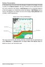
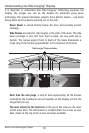
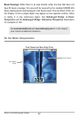
Side Imaging® Range - Images shown on
the right side of the screen are located on
the right side of your boat, and images
shown on the left side of the screen are
located on the left side of your boat. In this
picture, the sonar is pinging 150 feet on
each side.
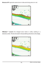
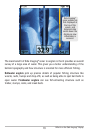
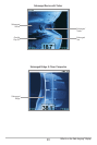
The water column shows the relative
depth of the water under the boat at a
given time. Variations in the width of the
water column show variations in the
distance to the bottom as the boat passes
over.
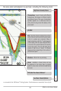
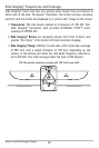
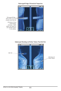
Shadows result from a lack of reflected
sonar from a particular area, and can be
more valuable for interpretation than the
sonar reflected by the object itself. Use
shadows to help you see the image in 3
dimensions, oriented in space. You can gain
insight into the actual shape of an object, or
the depth to which it has sunk into the
bottom, through shadows on the display.
Objects standing on the bottom cast a
sonar shadow. The longer the shadow, the
taller the object. Fish also cast shadows.
You can use the shadow to interpret how
close the fish is to the bottom.