


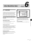
59
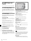
UMID Output and Display
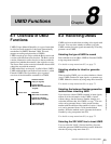
Chapter 8 UMID Functions
S+XXXXXXXm Y+D: Altitude data indicating the
distance from sea level is displayed in this format.
The meaning of the characters and strings shown is as
follows.
S (1st character): Indicates data from a Sensor. R is
shown for position data from the recording device
(Recorder), and T is shown for Target position data.
+ (2nd character): Indicates higher than sea level. −
indicates lower than sea level.
XXXXXXXm: Altitude data (in unit of meters).
Y: The number of satellites used to calculate position
data (hexadecimal)
D: DOP (Dilution of Precision) value
+ (between Y and D): Displayed when a support
apparatus was used. A space (blank) is displayed when
no support apparatus was used.
f LONGITUDE
Following W to indicate west longitude or E to indicate
east longitude, the longitude is displayed in degrees,
minutes, and seconds (seconds are shown in up to 2
decimal places).
Example: E134 59’23”00 for East longitude 134 degrees
59 minutes 23 seconds 00
g LATITUDE
Following N to indicate north latitude or S to indicate south
latitude, the latitude is displayed in degrees, minutes, and
seconds (seconds are shown in up to 2 decimal places).
Example: N34 59’23”32 for North latitude of 34 degrees
59 minutes 23 seconds 32
h ORGANIZATION
Organization code
i USER/COUNTRY
User code and country code