


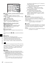
62
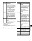
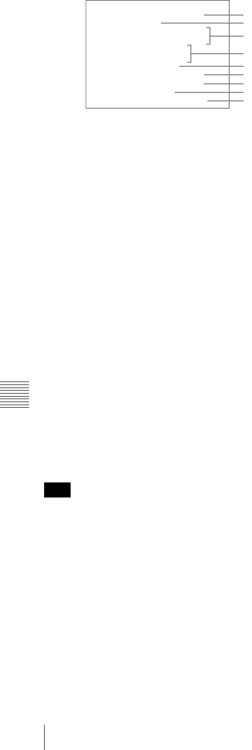
7-3 UMID Output and Display
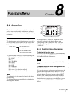
Chapter 7 UMID Functions
a Instance Number generation method and Instance
Number
The generation method is displayed as follows.
CP+16: “16-bit PRS (pseudo-random sequence) + Copy
No.” method
24PRS: 24-bit PRS method
others: Other than the above
When menu item 656 “MATERIAL NO.” is set to
“NEW”, it is generated by SMPTE method.
b Material Number generation method
SMPTE: SMPTE method
IEEE 1394 ZONE: IEEE 1394 ZONE method
IEEE 1394 RND: IEEE 1394 RND method
others: Other than the above
c Material Number
The material number is displayed in hexadecimal in two
lines.
The following items, 4 to 9, are contained in the Source
Pack.
d Date/Time
Date/Time data is displayed in two lines.
The upper line shows the MJD (Modified Julian Date)
contained in the Source Pack converted to UTC.
The lower line shows the data in unit count format
(hours : minutes : seconds : frame) converted to UTC.
The function for converting unit count to UTC works only
when the unit rate is 2 (24 frames), 3 (24/1.001 frames), 4
(25 frames), 6 (30 frames), or 7 (30/1.001 frames). For
other unit rates, the unit rate number and unit rate are
displayed in hexadecimal.
e Altitude
XXXXXXXXm: Altitude data indicating the distance
from the center of the earth is displayed in this format.
S+XXXXXXXm Y+D: Altitude data indicating the
distance from sea level is displayed in this format.
The meaning of the characters and strings shown is as
follows.
• “S” (1st character): Indicates position data from a
Sensor. “R” is shown for position data from the
recording device (Recorder), and “T” is shown for
Target position data.
• “+” (2nd character): Indicates higher than sea level.
“–” indicates lower than sea level.
• “XXXXXXXm” : Altitude data (unit: meter).
• “Y”: The number of satellites used to calculate
position data (hexadecimal).
• “D”: DOP (dilution of precision) value.
• “+” (between Y and D): Displayed when a
supportive geodetic apparatus was used. A space
(blank) is displayed when no supportive geodetic
apparatus was used.
f Longitude
Following “W” to indicate west longitude or “E” to
indicate east longitude, the longitude is displayed in
degrees, minutes, and seconds (seconds are displayed up to
2 decimal places).
Example: “E134 59’23.00” for “East longitude 134
degrees 59 minutes 23.00 seconds”
g Latitude
Following “N” to indicate north latitude or “S” to indicate
south latitude, the latitude is displayed in degrees, minutes,
and seconds (seconds are displayed up to 2 decimal
places).
Example: “N34 59’23.32” for “North latitude 34 degrees
59 minutes 23.32 seconds”
Note
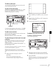
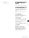
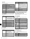
INSTANCE 24PRS XX-XX-XX
XX-XX-XX-XX-XX-XX-XX-XX
UMID INFORMATION
XX-XX-XX-XX-XX-XX-XX-XX
XX:XX:XX:XX +XX:XX
DATE/TIME 20XX/XX/XX
ALTITUDE XXXXXXXXm
LONGITUDE EXXX XX'XX.XX
LATITUDE SXXX XX'XX.XX
ORGANIZATION XXXX
USER XXXX COUNTRY XXXX
MATERIAL SMPTE
1
2
3
6
7
5
8
9
4